Seems like a no brainer right? Earth, science, they just go together. But Google Earth is way more than a glorified stand alone Google Map. There are so many cool and easy things to explore.
In Google Earth there are layers. Each of these layers are interesting facts, locations or events plotted on the globe. There are some pretty standard ones; roads, buildings, terrain. But there are some interesting ones that can support what you are doing in the science classroom. Here are just a few:
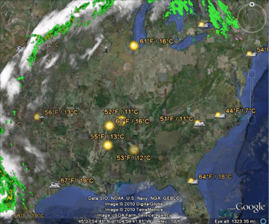
Weather-Yep, a weather layer. With a simple click of the mouse you can investigate cloud cover over Antarctica or Thunderstorms over China. Zoom in to your favorite location and you can see the local forecast for that area. You can download weather animations and load them in and watch how it changes all over the globe. There is also good information on how the weather is gathered and the sources they use.
Cousteau Ocean World-These are points all over the globe that provide information about different marine life in their natural environment. Discover the manatees off the coast of Florida, an octopus off the coast of France, or swimming elephants in Malaysia. (Ok, those aren't marine animals but still pretty cool. Each location has a short video and links to read more about it.

Animal Tracking- I have to be honest. I had so much fun with these I almost could not turn it off. A project called "Global Tagging Pelagic Tagging" has made available marine animal tracking data to the public so we all can learn about the patterns of animals. In this layer you find a tagged animal. For me it was the Northern Bluefin Tuna #5105032. Once I found him (or her. The gender was unknown) I learned so much! There are some cool facts about the tuna and I can see where their habitat is on the globe. I can also learn about the tag that they use to record the data. But the best part...I can follow the tuna along in Google Earth to see where it has been. So cool! There are tons of other animals like the blue whale, humpback whale, and some sharks.
State Of The Ocean-This is a very cool layer that has lots of sub layers to examine. One of the important things science teachers have to stress is why need to protect our oceans. Within this layer you can get almost up to the minute ocean observations from buoys all over the world, monitor ocean surface temperature, look at dead zones in the ocean and tons more. This layer is a great way to get kids talking about ocean protection and global climate change.
There are tons of other layers to explore. You can even turn off all the layers and just explore the ocean floor and examine continental divides, climb to the top of Mt. Everest or look at the rain forests in Brazil. If you are feeling really adventurous you can turn on the Flight Simulator and talk about the principals of flight. Oh and when you get really good, you can take the flight simulator underwater, across the ocean floor. (You can learn more about Flight Simulator
here.)
Google Earth is a great program with really endless possibility for any classroom. Check out these layers and tours. And be sure to head over to
Richard Byrne's blog
Free Tech 4 Teachers to pick up his awesome
Google Earth Guide.
How do you use Google Earth with your kids? Done something awesome? Share it in the comments!
 What we noticed was that there was a date in the bottom left side of the window when we were viewing our location in Google Earth. When we clicked on the date (1993) in the upper left side of the viewing area appeared the Historical Time Slider. It was very interesting to be able to go to a location on the map and then go back in time to see what the area looked like years before. We were able to look at the school location that we were at and see what the area looked like before the school was even built. There were even some photos showing the process of the school being built which the teachers thought was very neat and felt there students would enjoy it as well.